I have just updated my post in the forum with a more comprehensive way to tackle Gold Creek Peak on a mountain bike. Last night after a helacious day of repairing the bike from the last attempt I set out for another go at the peak armed with a newly purchased topo map. The ride started very well and it seemed as though I would get out before 10PM. That was not to be as I got temporarily lost and hike to do same hiking and back tracking. I reached the top at 3 hours and 20 minutes totally exhausted. I got back to the car at 10 PM with a bike that was again broken. Two spokes were broke, one on the hill climb, and one from the downhill. The corners were very sketchy let me tell you.
Author: Bill
-
Gold Creek Calling: Round Two!

Greetings, fellow thrill-seekers and nap enthusiasts! After two glorious days of recharging my adventurous batteries (read: napping like a hibernating grizzly), I’m feeling the pull of the wild once again. But let’s face it, that last attempt at conquering Gold Creek Peak wasn’t exactly a walk in the park (more like a crawl through a boulder field). I emerged more dust bunny than daredevil.
But fear not, for I am nothing if not resilient! Yesterday, I armed myself with the ultimate weapon: a topo map. Armed with newfound knowledge and a revised battle plan, I’m back for round two, baby! This time, my trusty steed (okay, fine, my slightly rusty mountain bike) and I are going all the way to the top, or at least as close as two wheels and one slightly bruised ego will allow. ♀️
-
This and that adventures
Boy am I sore. Read the reason from todays story on my web site. Well it is Monday and that means laundry and all that fun stuff. I m pretty slow at it today. I want to squeeze in some map and gear shopping also today. Other than that am looking forward to relaxing. The outdoors is calling me today as it is sunny and nice. Paul should be on the road today and I wish I was with him adventuring through Canada. Tomorrow I hope to get bike parts so I can ride to Sheep Mountain. I think Wednesday I may try to avenge last weekend blunder and do Gold Creek Peak.
-

Failing Gold Creek Peak
This Sunday”s adventure was a journey into bad decision making. I began the mountain bike portion just off route 200 East of Bonner on the Gold Creek Road. Its a pretty well traveled gravel road and you cant miss it. It right after Hayers Gulch. The route combines mountain biking up gold creek road to some logging roads, then hiking after mountain biking becomes to brutal. I cant be any more precise because I have not been successful at this climb….
The ride for the first hour was hard as the pack seemed to be slowing down progress. It seemed heavy and after a while really started hurting my back. Later I would find out that I was climbing a lot. Well, that and the fact that my brakes were dragging. At a fork in the road before I descended into the basin there was a sign. It posted two ways to get to each end of the Gold Creek Trail. I thought wow, this is interesting. Maybe a trail goes from Gold Creek Trail to Gold Creek Peak. That was my thinking. I took the right fork which was posted as 11 miles to the trail head and began a decent.
I reached another fork and determined that I was at the one hour mark of my journey and 8 miles in. Yea, that is another thing … I forgot my watch at home. Again the signs read Gold Creek trail head to the left and just a road number to the right. My plans were to go right and start hiking once I reached a ridge in which there was supposed to be a trail to the top. But then I started to re-think my plan. It was 8 miles to the trail head. If I had already done 8 miles than according to my map the road should take me pretty much right up next to my destination. Then I figured I would be so close I could hike the short distance and be back down the road in no time. So that is what i did … First bad decision. It was an 8 mile climb and every mile my heart told me that i made a bad decision. But I played out my decision hoping that I could still hike from the trail head and even maybe keep biking most of the way. it seemed as though there was extensive logging with roads everywhere.
The last 3 miles to the trail head I entered Lolo National Forest and the scenery was beautiful. Once I reached the trail head I switched my bike shoes for hiking shoes and set out. It seemed that my plan was working out and I kept an eye open for a right turn onto to trail that I could see according to my map went to the top. After 3 miles of hiking it became apparent that I was wrong and there was no ridge trail, at least not from that one. I reached a huge meadow and decided that the trip was a failure. I wanted to hike out the trail and just take some pictures. I snapped off a picture of a creek and it seemed like I might be happy with the day after all. I would just enjoy it I thought to my self. Somewhere in there Bad Decision #2 was made because the trail turned swampy and I was getting eaten alive by bugs. I had to turn around. I figured I would just go home. On my way back up the trail it started to rain.
I didn”t even get to my bike when I had to take shelter. It poured then started to hail. Al of a sudden a lightening storm ripped through the valley. It was very loud and scary. I huddled beneath my make shift shelter. I fell asleep after the thunder had moved on. I awoke and it was still raining. I waited at least an hour and decided that the rain would not pass. I proceeded to my bike. In the pouring rain I put on rain soaked bike gear and by the time I hit the road I was soaked. The downhill ride was very muddy and my bike and myself was just coated with mud. I could hear my chain crunching mud and just knew this trip would claim my drive train. By the time I reached the fork where I made the first bad decision the sun was back out and the mud was dried and caked to everything. Kind of cool I thought, how grueling. Oh but wait … the journey is only begun. I decided in my infinite wisdom that I would make a desperate attempt at the summit. Not by the original plan of hiking a ridge. It was getting to be late evening and there was no time. I decided to shed everything but one water bottle and ride to the top. From the views of the previous accent I could see logging roads all over the mountains. I figured that with out all my gear I would climb fast as furious. I would attack the mountain.
LOL Attacking the mountain … as I rode up the road the right this time I noticed that I wasn”t going any faster than before with a heavy pack. Later I would find out my brakes were dragging. I labored but did not turn back. i just wanted to see if my original plan was better as I would be back. I climbed and climbed. There was not ridge trail like the map showed so I kept riding anyway. I just knew I could find a logging road towards the top. One particular road seemed to be the one I was looking for and I took it. I was headed up and in the right direction. I wondered if I could take this road all the way. I soon was hammering along and expected to come around a corner and see the peak in front of me. Suddenly I seemed to be going down again. I figured that this road was going to descend into Gold Creek. I figured end of the road. As I turned around I found a trail going straight up. I figured it was the ridge trail and I could take it up to the next logging road. the trail fizzled out but I did find another road. This road also seemed to descend into the valley so I decided to ride back which seemed to be uphill of the road I taken before. well at least I figured I was higher.
I saw another road that switched back and went up over a saddle. This was my lucky break. There were sure to be logging roads on the backside too. I climbed more and I was as high as Black mountain when I got a glimpse of the Peak I was riding for. This road seemed to be the way to the top. I started to ride very fast and my spirits were lifted. It was getting late. I rode for a long time and realized that even if this road eventually went all the way to the top i might not make it. I was hungry, dehydrated, and it was getting late.
I drank the last of my water. I needed to take a shortcut. I decided to take a short cut and climbed with bike to the next road level. From there I realized that I would of never reached that point because the road I was on went into another valley. I rode towards the mountain. The road I was on reached a ridge and that was it. There were no more roads from here to the top of Gold Creek Peak. I could see the snow covered top but there was a long ridge in front of me. I started up the ridge on a slight trail but came face to face with a rock cliff.
I gave up. End of the road. I noticed that sun starting to set. I decided to hammer down to my gear. I came to the place that I hiked up. I tried to find the road I came from but got lost. I started to feel frantic. Finally I came out on a road that I had been on previously and felt relieved. But I had waisted to much time. Thankfully most of the return trip was downhill to my supplies. A very very long downhill. I even found myself having fun. I was getting huge air and freaking busting some fast downhills.
Once I got the main road back down to the fork where I stashed my stuff, it was all downhill. there was switch back after switchback. They were wide too with a good
view of oncoming traffic (there was none). I ripped around the corners. This ride at least was a cool mountain bike ride. As I reached my pack (at the fork of bad decisions) I realized how much I had climbed in so little time. I must be in shape. After some chocolate and water I headed back to the car.On the way out I had to climb up one more pass and then it was a great downhill to the car. I went fast and furious but of gone no longer as my back hurt so bad from carrying that backpack all day.
-
Gold Creek Peak Today
Good morning everyone. Todays adventure will take me to Gold Creek Peak. It is an approximately 7,181 foot mountain North East of Missoula. I will begin the mountain bike portion just off route 200 East of Bonner on the Gold Creek Road. Its a pretty well traveled gravel road and you cant miss it. It right after Hayers Gulch.
I will begin the first leg on my bike and I fully expect to make at least 8 miles in before I am forced to hike. From there though it would be a 8 mile hike to the peak. What would be better is if the trail is in good enough condition for me to proceed to the 12 mile mark and hike the remaining 4 miles. Who knows maybe ride the whole way like last week. I am not certain from the 8 mile marker on.
-
Feeling Rough
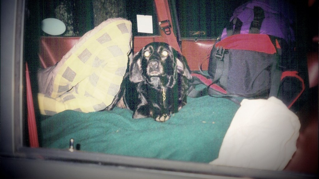
This morning I am feeling a little rough with and adventure yet to do today. I am really looking forward to today but maybe the weather will not agree. It is supposed to be thunder and strong storms. With such a long adventure today it is iffy. Yesterday I went hiking up some creek I cant remember the name. It was near the Idaho border. I got into the wilderness and wished I had not brought my dog Marcy. Tomorrow is a rest day but I have a ton to do. Next week I must get plans in place for next weekend as well as the books, repair my bike and take my car in for repairs.
-
Riding is Great, Dad is Sick
I woke up this morning to find out that my dad is having a rough time with his last kemo treatment. I will call this morning to give support and it was last night that I realized how many people are affected by cancer here in America. I think it would surprise most people just how many are affected. Yesterday was a new high in my new surroundings here in Missoula. I went with the Thursday Night Mountain Bike Group and we went on the most interesting and cool ride of the year. I will post what I remember in a forum post under Missoula Trails. Lets just say I had the time of my life. I have rode many trails but this one took the cake. Today I hope to do a ride this morning and maybe a hike in the afternoon although I am feeling a bit rugged after a hard week on the bike …. But I love it oh!
-

Lots of Mountain Biking Lately
After a night full of dreams, I’m feeling a bit weary today. Still, I’m eager to head out for a morning hike, then return home to sort out a few appointments and rest up for tonight’s mountain bike ride with friends. Yesterday was fantastic – I managed a three-hour mountain bike adventure up Blue Mountain and down Dead Man’s Ridge. I also enjoyed the “Out 2 Lunch” festival downtown and wrapped up the day with a hike at Lolo Hot Springs, which is likely where I’ll hike again today.
Paul will be arriving soon, so I need to arrange a dog sitter and also make plans to visit my aunt in Kalispell. A busy but exciting day ahead!
-
Creeping Headache
What a night! All day yesterday I had this creeping headache and exhausted feeling come over me. Sundays ride really took its toll on me. I was up all night with a bad headache but this morning I feel like a new man. I want to get some new pics up this morning then it is off to do some chores around town. This evening I hope to still do the Dead Mans Downhill MTB ride.
-
Grand Menard Discovery Trail
I’m writing from a shaded spot under a large Ponderosa pine on the Grand Menard Discovery Trail, near the nine mile ranger station.
Today’s my chore day, but I had to take Marcy for a morning walk. It’s just too beautiful outside to stay in.
Yesterday, I had an amazing ride. I biked up Miller Peak, a climb that took an hour and a half. At over 7000 feet, it’s the highest I’ve ever gone on my mountain bike. The descent was even more thrilling. The climb was exposed and the trail, though a jeep trail, was in excellent condition.
Tomorrow, I’m thinking of tackling Dead Man’s Ridge off Blue Mountain. Or maybe I’ll save it for Wednesday and do Mount Sentinel instead. A friend challenged me, saying the top is nearly impossible. I’m eager to give it a try.
-
Miller peak maybe
Hopefully todays bike ride will have better results. Yesterday was cut short due to a bear run in… I plan to use the mountain bike today to get as close to my final objective as possible then ditch it for the final accent. All details are unknown as I have searched the web high and low for trail descriptions. There are none. I will travel up miller creek to a gravel jeep trail (see map) on the left. From there I will climb and about a mile up is as far as I can be assured of. From there I may just have to ditch the bike and take a direct ridge. Have a good Sunday all.
-
Grizzly Creek Today
Today’s adventure will take me to Grizzly Creek. It is supposed to be a remote getaway with hardly any chance of meeting up with other humans. The trail head is up rock creek 30 miles east of Missoula. I will be climbing up Grizzly Creek and will connect up with the Sapphire Mountain Range. There is also a mountain top spring on top and that is my destination. This ride is 20.4 miles round trip and probably includes a lot of unridable sections.
-
Raining Outside
It is raining outside and yesterday I had a off day. My web site has benefited from this day inside. I was supposed to get my car tuned up and get in a couple hikes. I did not and I guess I was just worn out mentally and physically. I feel better today and I am raring to go on a mountain bike ride. The problem is that it is raining. I hope for a clearing in the weather so I can get out. I guess Ill post some pictures if it gets too bad outside. Cheerio!
-
TNR Does Marshall Canyon
Good morning all. Last night I went with the Thursday Night Mountain Bike Group. We went on some old and new logging roads up Marshall Road and near the Marshall Ski Area. On the way down we hit some sweet single track. After the ride we hit a burger joint and celebrated our ride with some grease. I was warned that next weeks ride will be a dowser. We will be getting done in the dark. Sounds like fun.
Got to get some coffee … Ok, there!
Today I must get my car serviced. I am nervous because I don't have a job. I might do most of it myself and get the other stuff like tire rotation done at the import place. Mostly though I plan to spend some time in the mountains hiking. The weather is awesome so I must bid adieu.
-
Marcy Kills Family
by Paul Bardis Kicked off the morning with a hike at Blue Mountain, made my way to Blue Point—pretty stellar views. But, things took a turn when Marcy went full predator mode on a bird family. Mom and all the little ones, gone. Just like that. She darted into the thick brush before I could even blink. Looks like that was Marcy’s final hiking adventure in any spot that’s got more life in it than a rock.
Just rolled back from the Out to Lunch festival downtown—felt like the whole city and their pups were out soaking in the vibes. Bagged my third sunburn of the season, a real trophy. Now, on a less sunny note, gotta track down a VW dealer. Later!
-

Project Vote Smart Link Added
Hello everyone, I have found a great resource on the web for those of you who just want relevant information about candidates without all that political crap. As you all know I hate politics and this site seems to have the information that I am looking for. Please friends, refrain from emailing me to let me know your views. Check em out … Vote Smart . Feel free to comment!
-
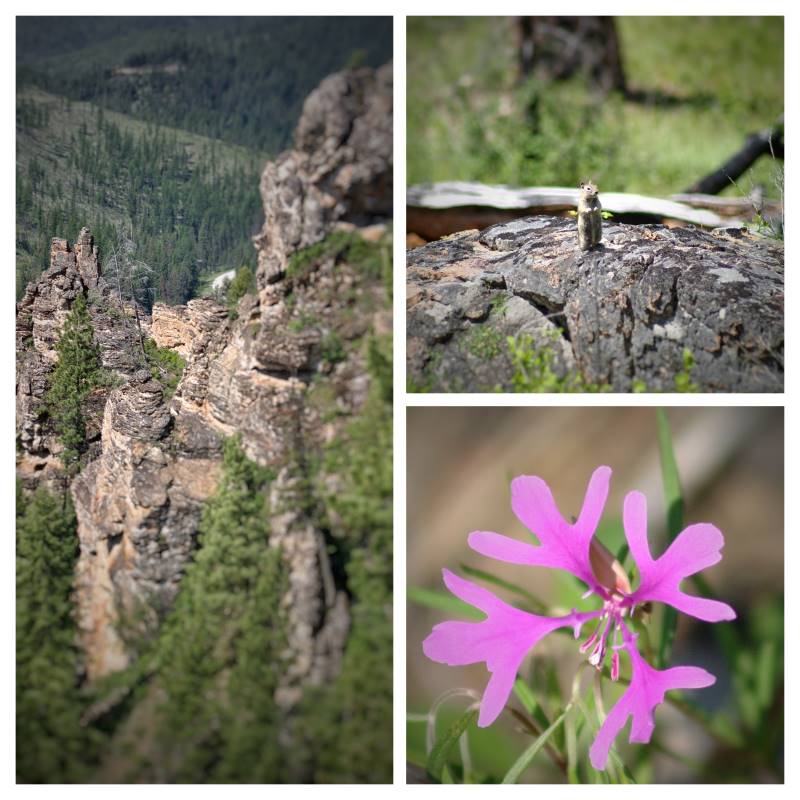
My Home
I just got back from a awesome hike. I did Blue Mountain on the South Western side of Missoula. It took me 6 hours and 45 minutes. What a hike. On the way up it went from sunny to downpour rain. Then on a ridge it started to snow and it got so cold I almost turned back.
Once off the ridge for the final accent I warmed back up again and when I reached the summit it was sun shining again. I got great views of the Mission Range and Lolo Peak.
On the way down I just got off as a huge blizzard engulfed the mountain. I also got great pictures of the storm.
As I descended the wild flowers were so beautiful I couldn’t believe it. Every color … So awesome. As I came down I took three breaks in open fields of flowers and enjoyed the view in sunshine.
Oh, what a day. I love it here. My home.
